Archive for category Colonial
In my mind I’ve gone to Ft. Ticonderoga
Posted by John Dickson in Brown Signs, Colonial, Personal memory, Public History on November 16, 2012
If people experience history best through personalizing it, then it is likely what we get out of a museum is something that connects directly to our personal experience.
That was the case during a visit this fall to Fort Ticonderoga on the New York side of Lake Champlain. The fort which occupies a strategic position on the southern tip of the lake played a role in both the French and Indian War and the Revolutionary War in the 1700s. The strategic part was made clear in a map at one of the displays showing the water route taken down the lake from Canada, and then across a brief stretch of land over to the Hudson River, which leads all the way to New York City.
So, how did my wife and I experience this personally?
For one, we skipped the musket demonstration which drew off the small crowd early on Sunday morning, leaving the rebuilt fort and room displays to ourselves (we hate crowds and are not too keen on guns either.)
Second, we lucked into the only tour available during our time frame, of the King’s Gardens on the property. The fort has succeeded in planning gardens and pasture which period soldiers may have used (albeit surrounded by electric fence at night.) The gardens we focused on, though, pertained to the private property owned by the Pell family, ancestors of Senator Claiborne Pell from Rhode Island. At the time, we had been busy re-landscaping our newly renovated house (on a much smaller scale, admittedly), so these beautifully cared for gardens and trees captured our attention.
Third, we were instinctively drawn to any connection to our home town of Pittsfield in the display. We skipped right past the names of Ethan Allen and Benedict Arnold and focused on a name neither of us had heard previously, a Pittsfield native, Colonel John Brown. We saw a plaque honoring him as we entered, and we spent more time in front of the displays explaining his leadership of a three-day assault on the fort in September 1777, which helped lead to the abandonment and subsequent destruction by British forces of the fort two months later. We learned John Brown was killed later in the war at the age of 36.

Soldiers at Ft. Ticonderoga. Credit: M. Dickson
Finally, we zoomed in on the motivations behind the tour guide/reenactors who, both paid and volunteer, filled the environs, even with their children. We assumed they probably had spent the night there, at least some of them. Our tour guide, in period uniform, explained he bought his uniform from a store in the U.K., with special wool and buttons and sewing techniques, all at a fairly expensive cost. We later overheard several of the uniformed guides discussing amongst themselves where they had procured various pieces of their outfit. Here again, we personalized, admitting this was not anything we would ever find ourselves doing, but frankly pleased the fort was able to attract people who put such time, energy and expense into this hobby.
As we were heading out, we noticed that others were studying in detail the musket displays, which we had zoomed right by, but stopped for an equally intent examination of the maps which showed prominently western Massachusetts, Pittsfield and even our neighboring lake.
Christmas in 1776
Posted by John Dickson in Brown Signs, Colonial on December 13, 2011

Order: "Hop on with cannons and horses...."
“The worst army in the world confronting the best.” That’s how the docent at the Johnson Ferry house at Washington Crossing State Park described the state of George Washington’s 2400 soldiers once they had landed and regrouped on the New Jersey side of the Delaware River.
The crossing of the Delaware on Christmas Day — really at night — has been labeled one of the “pivotal moments in American history.” You can see why. Had Washington failed, had his troops rather than the Hessian mercenaries in Trenton, been defeated, the revolutionary cause would have suffered a fatal blow.
In his book, Washington’s Crossing, David Hackett Fischer lines up all the disasters and problems which risked and forced changes into the plans for this bold three-pronged attack on Trenton. Starting with a driving sleet and snow storm and dangerous ice flows in the river, two of the three landing parties were unable to reach the other side of the river. Washington’s own crossing at Johnson’s ferry started late, took all night long, and lost him the element of surprise which a night-time 9-mile march to Trenton would have given him.
It was early December when I visited the site. The river was overflowing the banks with a current strong from a wet fall and previous days’ rains. Even with 45 degrees of daytime sun, no wind and REI clothing, I was cold. Replicas of the Durham boats (large canoes with high walls) and the ferry barges looked to be no match for the strength of that river.
Where I stood in the Johnson ferry house, next to the half-a-wall-length fireplace, was where the docent said Washington met with his aides to decide whether or not to continue on to Trenton. I thought they were the lucky ones, inside. It was easy for them to decide to keep going, especially when I learned some of the soldiers didn’t even have shoes.
I thought of taking mine off and walking around the grounds, but I was already cold. I walked down to the river in my Rockports, and tried to imagine the boatsmen – the Marblehead Massschusetts militia-sailors and the ferry operators – working all night long. They dragged their boats up the NJ side of the river; let the current take them down and over to the Pennsylvania side; and then after loading up with men, horses, cannons, they maneuvered their shaky vessels further down and back over to the NJ side. Then they did it again, and again over a ten hour stretch.
Ten minutes later I was back in my car. I figured out how Washington and his army, after so many things had gone wrong, was able to surprise the Hessians and then defeat them the next day at Trenton. No one, not the Hessians, nor I, 235 years later, could have imagined anyone undertaking a crossing march in such adverse elements.
Give Washington credit, even if he was warm. He could convince these soldiers, miserable and cold, after such a crossing to continue on, in the snow, for a nine-mile march and then attack and defeat the most formidable army the world knew at that time.

"and cross this, at night, in driving sleet. Then march 9 miles to Trenton and fight the best army in the world."
If THESE Walls Could Talk
Posted by John Dickson in Berkshires, Colonial, History in our surroundings on October 26, 2011

Can you find the stone wall? Photo JDickson
Walk in the woods almost anywhere in New England or drive along almost any road and you are likely to come across a stone wall. We take them for granted. We rarely pause to consider who built these walls, when were they built or even why.
Last summer, I did my own personal stone wall reenactment. I built a stone wall. Really it was just moving rocks which came out of the foundation for an addition on our house. I had the help of an excavator for three very large boulders. Other than that, it was a wheelbarrow and my own feeble arms carrying and placing these rocks. I got about to a length of about 30 feet and a height of 3 feet at most before I realized that I had bit off more than I could chew. While it looks nice, I have no illusions that it will last as long as the stone walls I saw recently walking up Mt. Greylock, or similar ones in the woods around Rangely Maine.
Several things leap to mind immediately on seeing these walls. First, they are now in the middle of woods. When they were built, they were most likely thrown together to demarcate fields and pastures. These thick woods were once pastures. How quickly have they reverted back to their natural state! These are small plots of farmland they mark off, probably accounting for why farming in this region lost out to the much larger, commercial and industrial farms of the MidWest.
Second, the walls go on and on, much longer than my miserable little 30 feet, extending along and breaking up 10 and 20 acre plots. This was a monumental exercise therefore, one which had to take place over many years. If one author estimated that it would take two men to lay 10 feet of stone wall in one day, why did it take me so long to go just 30 feet? Stone wall studies often cite an 1871 report undertaken by the Department of Agriculture, Statistics of Fences in the United States. There, it is estimated that Connecticut had 20,505 miles of walls, Massachusetts perhaps as much as 16,000 miles and New York 95,364 miles!! One author surmised that it would have taken 15,000 men 243 years to construct the stone walls in New York and New England. That may surpass the pyramids.
Next, just how many rocks could a farmer move from a field? He probably had help, in the form of oxen and wooden sliders, his sons, or tenant farmers or even slaves. The earth kept providing stones for the farmers to move, each winter would churn the earth to provide another crops of stones to be moved.
And, did he follow a technique that was widely accepted? The old adage of “one rock covering two and two rocks covering one” probably gave the wall its height, but not its broad width, without mortar? Perhaps, he just threw them in a pile.
These walls do speak. They take us back to a different life, a back-breaking life, of subsistence farming, of years of the same kind of drudgery, work with little change. And then it changed. Our human attempts to control our environment were in the end short-lived.
Why are battlefield sites so peaceful
Posted by John Dickson in Brown Signs, Colonial, History in our surroundings on August 12, 2011
Ever heard of the Battle of Hubbardton? Neither had I, until this past weekend when driving south in Vermont we came upon the “brown sign.” Turns out, it is the only battle fought “entirely in Vermont” during the Revolutionary War. The “entirely” is important since within a month there was a second battle in Bennington, Vermont in the southwestern corner of the state, bordering Massachusetts and New York. Turns out, as well, that it was a pivotal battle on July 7, 1777 to forestall the British in their march from Ticonderoga, in their belief that they could contain the revolution to the rebellious New England colonies by controlling the Hudson and cutting them off from New York and all points south. Or, at least that’s what we read in the clean and informative visitor center.
I have found over many years of reading history the difficulty of conveying the unrolling of a battle through the printed word. Too many groupings, elements and terrain leave me confused. Hubbardton was no different, but they did have a relief map with lights which lit up as the taped narrator walked the observers through the chronology of the colonists holding the ridge, then giving way, but seeing a vulnerable opening in the British flank which did allow them to achieve one objective of delaying the British advance south.
Moving from that well-designed explanation to the actual site proved a setback, as we tried to imagine troop movements coming from which valley? Proceeding to which points on the ridge and down which hill and where was the log/brush fence?
It didn’t matter to us, since we were more interested in the beautiful scenery on a summer Sunday looking out over the forests and the hills. The only sounds were the wind through the trees, an occasional bird, and our voices.
It was so serene it was hard to imagine the fog of war where we standing no matter how long ago, and how quickly the battle transpired on just one morning. The fact that over 100 soldiers died where we were walking added an eerie presence to the serenity. The field becomes less a battlefield than a cemetery.
This calm proved no different from other battlefields I have visited, like Gettysburg or Little Bighorn or Isandlwana in South Africa.
We learned there is a large reenactment at Hubbardton every year, and since next year is the 240th anniversary, the congregating reenactors will reach the hundreds.
Given the deaths on the battlefield, shouldn’t there be a memorial service instead?

The view from Monument Hill, with battlefield visitor center. Hubbardton, Vermont
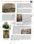
If Only the English Had Listened to Paul Revere
Posted by John Dickson in Colonial, Public Affairs on June 7, 2011
We all make mistakes. Some of us have an easier time admitting that we made them though. Some of us are in the national spotlight and are making mistakes to stake out an exclusive claim on our nation’s independence heroes for our own political ends.
Cue Sarah Palin and Michele Bachmann, two prominent political figures. Does it matter that they are on the right of the political spectrum? Actually, it probably does since they both channel the colonists who engaged in the 1775 tea party to demand liberty.
In mid-May, Minnesota Congresswoman Michell Bachmann was “not” campaigning in New Hampshire which traditionally holds the first Presidential primary elections, tried to ingratiate herself with the local crowd by saying “You’re the state where the shot was heard around the world in Lexington and Concord.”
A few weeks later, former Alaska Governor and VICE-PRESIDENTIAL candidate (!) Sarah Palin was also “not” campaigning in Boston when she tried to re-write the role of Paul Revere in claiming our liberty this way: “He who warned the British that they weren’t going to be taking away our arms, by ringing those bells, and making sure as he’s riding his horse through town to send those warning shots and bells that we were going to be secure and we were going to be free.”
It’s great material for John Stewart or David Letterman. They might even say it’s too easy for them.
Their followers try to deflect, by saying these missteps do not really matter; that the liberal media is out to “get” them while giving Barack Obama a pass. Most likely, colleagues on their side of the political aisle are fuming, as these gaffes detract from serious candidates who have announced they are running for President.
It would be interesting to imagine members of their staffs, trying to prep and brief them for their next non-campaign stops. They will either have bookmarked Wiki-Pedia to get the latest tidbits of history in each stop or they are carrying around with them a seventh grade U.S. history textbook, maybe even copies of Scholastic magazine.
And, it would be more than entertaining if the other Wiki (of leaks fame) could dredge up some of the cables from other countries’ embassies in the U.S. so that we could see how they are trying to interpret the politics of our next Presidential election.
Here’s how the cable might read from the UK Embassy: “So Paul Revere was warning us? If only we knew? Had we listened and just allowed them to keep their guns for hunting, North America still might be our colonial empire.”
-
You are currently browsing the archives for the Colonial category.

A memoir in letters. Excerpts from letters that a father wrote his children each week for almost 30 years, full of the mundane and poignant, the witty and wise. Stories from a different time, from a small town in Connecticut.
History Shock
 Pleased to announce the publication of my book in May 2021 by the University Press of Kansas. This collection of “stories with a history” narrates incidents over the course of my career in the Foreign Service when historical understanding – or lack of it – got in the way in the conduct of day-to-day diplomacy.
Berkshire County’s Industrial Heritage

Check out this book on the nineteenth century mills and those who owned and worked in them. Available through Arcadia Press or Amazon.
Slide Show – Getting to Yes, Woman Suffrage in the Berkshires and Beyond
-
Slide Show – Intersections, Pittsfield’s Neighborhoods
-
Slide Show – Turning Points


Slide Show – Preserving the old Berkshire Athenaeum
 Thomas Allen donated $50,000 to build the Athenaeum in 1876.
 A yong architect from New York, William Appleton Potter, had his design selected for the new Athenaeum.
") The original architectural drawing of the front elevation of the Athenaeum
The original architectural drawing of the front elevation of the Athenaeum An early photo of the High Victorian Gothic building, pointed arches, twin gables, multi-color stone patterns,skylight, stained glass windows
 Majestic, quartered oak tresses in the addition built in 1896
 Proposed new library design, in 1944
 Bulging of stonework on from of building required drastic measures to shore up front, in 1979
 A restored skylight is returned to the roof in repairs undertaken in 2001
 Stained glass window on west gable, showing steel tie placed in 1979 stabilization repairs
 Masonry work begins on the Athenaeum in the deep of winter
 Removing the stained glass panels for repair
 Cracks in the masonry
 More cracks in the masonry
 Lifting the capstone off the east gable, the first stone removedd